Contents

  •  


Ministry of Forests, Lands and Natural Resource Operations

Snowmobile Closures

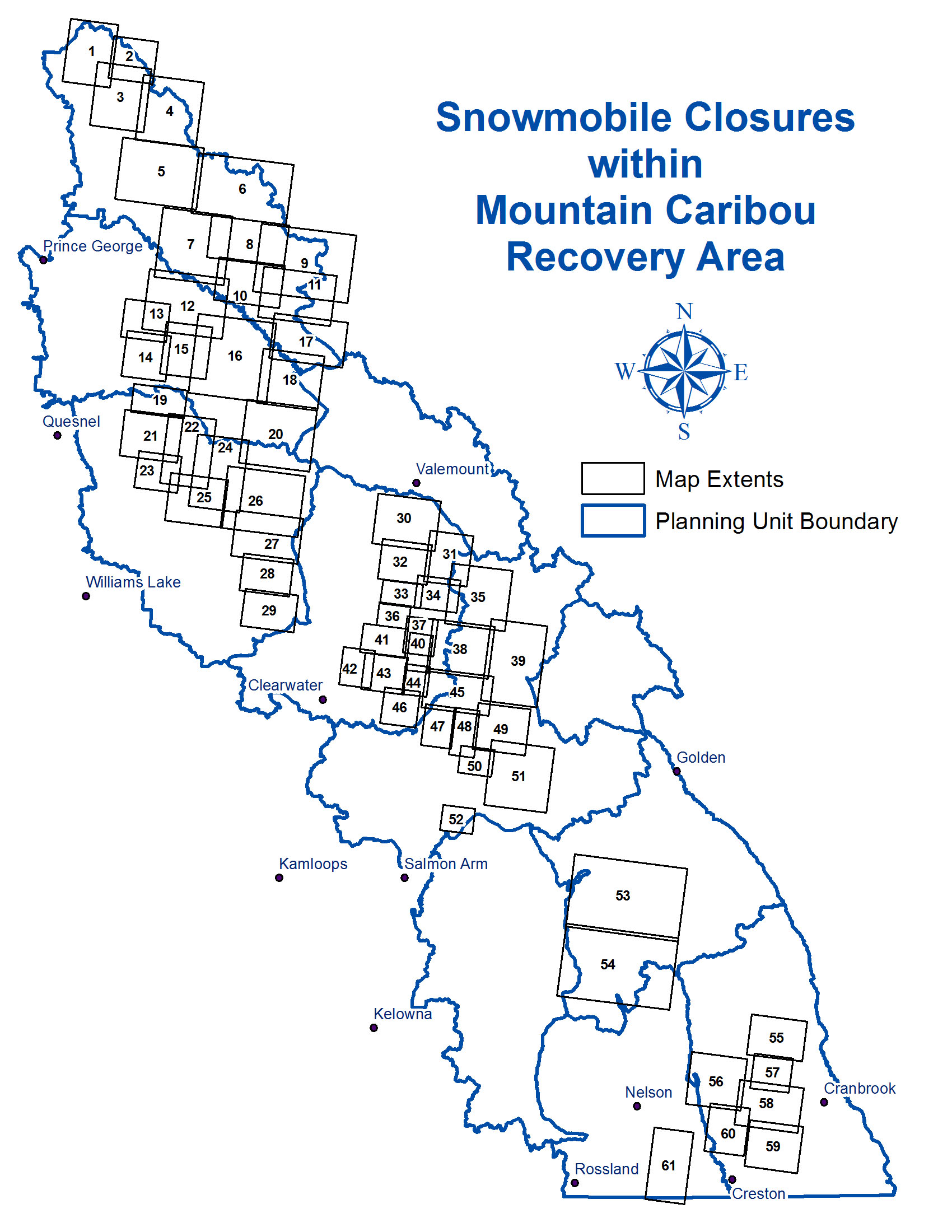
Under the Mountain Caribou Recovery Implementation Plan, scientists recommended over one million hectares across the mountain caribou range be closed to motorized winter recreation to facilitate recovery of caribou populations. Since 2009, government has closed areas to snowmobile use across the Mountain Caribou range in order to support population recovery. The maps below show the areas open to snowmobiling and areas closed under the Wildlife Act. These maps can be viewed and downloaded. Maps are georeferenced PDFs so they can be used in mobile applications to determine your location relative to boundaries, open riding areas and trails.

The closed areas have been amended with BC Reg 74/2011 effective April 27, 2011 and BC Reg 130/2016 effective July 1, 2016.

  » Download closure areas to a GPS device or Google Earth

Snowmobile Use within Caribou Recovery Area

Maps

  1. Mt Reynolds Closure [24x36 | 85x11]
  2. Mt Wendt Closure [24x36 | 85x11]
  3. Table River Closure [24x36 | 85x11]
  4. Hominka River Closure [24x36 | 85x11]
  5. Otter Closure [24x36 | 85x11]
  6. Parsnip Closure [24x36 | 85x11]
  7. Farmer Closure [24x36 | 85x11]
  8. Sande Closure [24x36 | 85x11]
  9. Kakwa Closure [24x36 | 85x11]
  10. Old Herb Closure [24x36 | 85x11]
  11. Walker Creek Closure [24x36 | 85x11]
  12. Sugar Bowl Mountain [24x36 | 85x11]
  13. Wolverine North Closure [24x36 | 85x11]
  14. Wolverine South Closure [24x36 | 85x11]
  15. Hooker Closure [24x36 | 85x11]
  16. Goat River Closure [24x36 | 85x11]
  17. Mt Rider Closure [24x36 | 85x11]
  18. Mt Halvorson Closure [24x36 | 85x11]
  19. Two Sisters Mountain [24x36 | 85x11]
  20. Cariboo River Closure [24x36 | 85x11]
  21. Barkerville Mountain Closure [24x36 | 85x11]
  22. Mt Patchett Closure [24x36 | 85x11]
  23. Cariboo Mountain Closure [24x36 | 85x11]
  24. Ishkloo Creek Closure [24x36 | 85x11]
  25. Grain Creek Closure [24x36 | 85x11]
  26. Quesnel Lake Junction Closure [24x36 | 85x11]
  27. Bill Miner Closure [24x36 | 85x11]
  28. Eureka Peak Closure [24x36 | 85x11]
  29. Mica Mountain Closure [24x36 | 85x11]
  30. Allan Creek Closure [24x36 | 85x11]
  31. Dominion Creek Closure [24x36 | 85x11]
  1. Chappell Creek Closure [24x36 | 85x11]
  2. Thunder River Closure [24x36 | 85x11]
  3. Bone Creek Closure [24x36 | 85x11]
  4. Howard-Foster-Encampment [24x36 | 85x11]
  5. Blue River Closure [24x36 | 85x11]
  6. Foam Creek Closure [24x36 | 85x11]
  7. Map 2 - Revelstoke-Monashee-Selkirk [24x36 | 85x11]
  8. Map 1 - Revelstoke-Monashee-Selkirk [24x36 | 85x11]
  9. Groundhog Closure [24x36 | 85x11]
  10. North Lion Closure [24x36 | 85x11]
  11. Maxwell Closure [24x36 | 85x11]
  12. South Lion Closure [24x36 | 85x11]
  13. Shannon Creek Closure [24x36 | 85x11]
  14. Map 3 - Revelstoke-Monashee-Selkirk [24x36 | 85x11]
  15. Reg-Christie Closure [24x36 | 85x11]
  16. Bischoff Closure [24x36 | 85x11]
  17. Mt Grace Closure [24x36 | 85x11]
  18. Caribou Basin [24x36 | 85x11]
  19. Bourne Glacier Closure [24x36 | 85x11]
  20. Standard Peak-Sale Mtn-Frisby Ridge [24x36 | 85x11]
  21. Queest Mountain Closure [24x36 | 85x11]
  22. Central Selkirks North Closure |[24x36 | 85x11]
    Central Selkirk Snowmobile Management Area
  23. Central Selkirks South Closure |[24x36 | 85x11]
    Central Selkirk Snowmobile Management Area
  24. Buhl Creek Closure [24x36 | 85x11]
  25. South Purcells Kootenay Lake N [24x36 | 85x11]
  26. Mathew Creek [24x36 | 85x11]
  27. South Purcells Cranbrook [24x36 | 85x11]
  28. South Purcells Creston [24x36 | 85x11]
  29. South Purcells Kootenay Lake S [24x36 | 85x11]
  30. West Kootenay - South Selkirk [24x36 | 85x11]
» Download these areas to your GPS